Back کندال AZB Кендал Bulgarian Kendal Catalan Kendal (lungsod) CEB Kendal Welsh Kendal Danish Kendal German Kendal Esperanto Kendal Spanish Kendal Basque
| Kendal | |
|---|---|
| Town | |
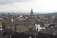
 View of Kendal, with the clock tower of the Town Hall (centre) | |
Location within Cumbria | |
| Population | 29,593 (2021 census)[1] |
| OS grid reference | SD5192 |
| • London | 223 miles (358.9 km) SSE |
| Civil parish |
|
| Unitary authority | |
| Ceremonial county | |
| Region | |
| Country | England |
| Sovereign state | United Kingdom |
| Post town | KENDAL |
| Postcode district | LA9 |
| Dialling code | 01539 |
| Police | Cumbria |
| Fire | Cumbria |
| Ambulance | North West |
| UK Parliament | |
Kendal, once Kirkby in Kendal or Kirkby Kendal, is a market town and civil parish in the Westmorland and Furness district of Cumbria, England. It lies within the River Kent's dale, from which its name is derived, just outside the boundary of the Lake District National Park.
In the Domesday Book of 1086, the area was collected under Yorkshire. The area came under the Honour of Lancaster before the barony split. The town became the Barony of Kendal's seat, in 1226/7 this barony merged with the Barony of Westmorland to form the historic county of Westmorland with Appleby as the historic county town.[3] In 1889, it became the county town. Under the 1974 reforms, it became the administrative centre of the South Lakeland district. The town became Westmorland and Furness district's administrative centre in a 2023 reform.
It is 8 miles (13 km) south-east of Windermere and 19 miles (31 km) north of Lancaster. At the 2011 census, the town had a population of 28,586,[4] making it the second largest town in Westmorland and Furness after Barrow-in-Furness. As of the 2021 Census, its population was 29,593. It is renowned today mainly as a centre for shopping,[5] for its festivals[6] and historic sights, including Kendal Castle, and as the home of Kendal Mint Cake. The town's grey limestone buildings have earned it the sobriquet "Auld Grey Town".[7]
- ^ "Kendal". City population. Retrieved 25 October 2022.
- ^ "Kendal Village Council – Home – Old Market Village, Lake District – Kendal, Cumbria, UK". Kendal Town Council. Archived from the original on 13 April 2018. Retrieved 24 April 2018.
- ^ F.A. Youngs, Guide to the Local Administrative units of England, Vol.II, Northern England, London, 1991
- ^ UK Census (2011). "Local Area Report – Kendal Parish (E04002617)". Nomis. Office for National Statistics. Retrieved 7 May 2021.
- ^ "Shop". Kendal Town.
- ^ "Events and Festivals - Visit Kendal | Kendal | Cumbria". Kendal Town.
- ^ Cumbria Tourist Guides. Retrieved 4 August 2020.

